The map above is only a sample of the kind of information available about our community that we can produce. As you look it over we think that you'll see things missing in the categories we've selected to highlight, or think of other things that should be included. You'll probably think of ideas to improve how we've approached the project. We hope that you do.
Our goals for this mapping project are to produce, and promote the development of maps in the Washington, DC metro area. This map is just a draft to get the process started - web based information sharing is seen down the road...
Getting the right people involved is our first step, and this draft map is how we hope to do that. We hope that seeing what potential a map like this has will draw you into the process as an active participant.
We want to identify the right combination of information on the maps so that they can begin to tell a story about our communities that would interest residents, teachers and visitors. Can we interest you in working with us to produce Urban Ecology Maps for the DC Metro area?
There are several questions that arise right away when thinking about what we hope to achieve. Who is the audience for such a map? What are we trying to show people? What is the right scale? (the larger the area we try to cover, the less information we can put on the map) What information should we put on the map? Perhaps most important, who should be involved in answering these questions?
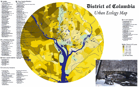
Having just one map of the D.C. region inside the beltway may not be workable. In order to have a map scaled right to show details of different information categories we may need to select a smaller area, such as just Washington, D.C. Other communities in the region may feel the same way and want to design a map of Silver Spring or Alexandria. We'd like to help as many maps get started as seems reasonable. The kind of information we think is desirable would both educate as well as provide information of where things are. Showing urban gardens tells us something about a community as well as just where to find them. Showing the location of superfund pollution sites along with income levels can tell us something about a whole region.
We want to help create new ways of thinking about and seeing our communities by emphasizing environmentally healthy and locally focused awareness of where we live. We hope to involve people in the process of creating maps that will lead to thinking about the metro area in a way that highlights and celebrates our experience of where we live.
We see the map as helping to accomplish two things.
The map should help us to identify areas of concern that might enable us to work together more closely. We hope that the map will be a mechanism that contributes to stronger relationships between community leaders. We also hope that it will educate people about a wealth of assets in your community that don't typically appear on maps - and will also identify some negatives that may not be apparent. Taken all together the information on the map should be descriptive of our communities in a way that might stimulate thought and discussion about the relationships between the institutions that shape the places we live. Please contact us to stay on our mailing list for updates and meeting invitations.
To contact us please write Larry Martin, 6612 Piney Branch NW, Washington, DC 20012, call 202.829.7112 or email at martinlrr@netscape.net.
We are also looking for people or groups willing help with the Internet side of this project. It needs a permanent web host. We would like to be able to make the map interactive, allowing people to focus on different data themes or layers. We would like to see the web used as a way to share data about the DC Metro area.
ABOUT THE MAP
The DC Metropolitan Urban Ecology Map is a project of Sustainable Community Initiatives and the DC Metro Chapter of Architects, Designers and Planners for Social Responsibility. Data for the map was generated by "Community 2020," software developed for the US Dept. of Housing and Urban Development. Among 2020's assets are census data for the entire country, (including streets). The map was produced by Karl Musser using ESRI ArcView software. This map is affiliated with the Green Map System and utilizes GMS Icons Version 2.
DC Links: